
Scenic Solutions has conducted many projects into measuring and mapping scenic quality, assessing the visual impact of developments and advising on policies. This section provides access to the reports on these projects.
The map of South Australia indicates the location of many of these projects. This omits the study of the Lake District in England.
The projects are summarized here and links provided to the project reports. Click Summary of landscape studies for a summary of these studies.
In addition, Scenic Solutions has also carried out a landscape assessment project of the Lake District in England, an assessment of the World’s Best Landscapes, an assessment of the visual impact of wind farms in New South Wales, Victoria and South Australia, and also a survey of British councillors of the visual impact and acceptability of wind farms in Britain.
Click on the following list of projects.
Landscape Quality Assessment of South Australia Click here
Assessing the Visual Impact of Wind Farms in Coastal and Inland Locations Click here
Assessing the Scenic Amenity of Large Remnant Trees in Agricultural Land Click here
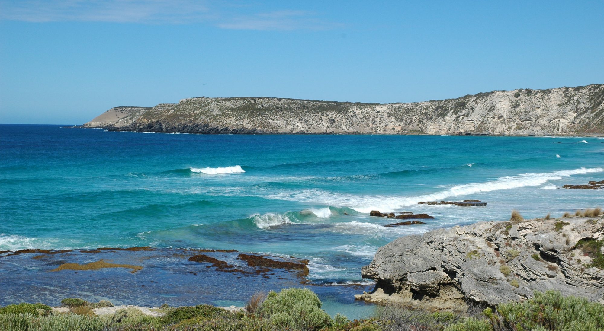
Measuring and Mapping the Scenic Quality of the South Australian Coast Click here
Assessing the Impact on Scenic Quality of Coastal Developments Click here
Measuring and Mapping the Scenic Quality of the Barossa Region Click here
Assessing the Scenic Quality and Landscape Characteristics of the City of Victor Harbor Click here
Measuring and Mapping the Scenic Quality of the River Murray, Lakes and Coorong Click here
Assessing the Visual Effects of Development along the River Murray Click here
Measuring and Mapping the Scenic Quality of the Flinders Ranges Click here
Generic Landscape Survey Click here
Lake District National Park (UK) Landscape Quality Assessment Click here
Mount Lofty Ranges Landscape Quality Assessment Project Click here
World’s Best Landscapes Project Click here
A Community Survey of the Visual Impact and Acceptability of Wind Farms in Australia Click here
Survey of the visual impacts and acceptability to councillors of wind farms in Britain Click here
Application of the Community Preferences Method, 2000 – 2020 Click here
Landscape Quality Assessment of South Australia
Andrew Lothian’s PhD dissertation was on the subject: Landscape Quality Assessment of South Australia. The thesis explored the philosophical, perceptual, psychological and cultural aspects of landscape quality, reviewed methodologies internationally, and developed and applied a methodology to measure and map landscape quality for the whole of South Australia, a State of Australia nearly one million square kilometers in area. The thesis (444 pages) is available via the University of Adelaide Library: http://digital.library.adelaide.edu.au/dspace/handle/2440/37804

Assessing the Visual Impact of Wind Farms in Coastal and Inland Locations
Dr Lothian conducted private research to assess the visual impact of wind farms in coastal and inland areas of South Australia. It examined 21 coastal and 47 inland locations. The research determined that wind farms diminished scenic quality in all coastal locations. For inland areas, where the prevailing landscape quality was low (< 5.1), the presence of a wind farm actually enhanced scenic quality through introducing interest in an otherwise dull landscape.


Results of the research were presented at several international conferences including the European Wind Energy Conference in London in 2004. A paper was published in Geographical Research, 46:2, June 2008, 196 – 207.
Paper: Lothian, A., 2008. Scenic perceptions of the visual effects of wind farms on South Australian landscape (11 pages, PDF 0.3 MB). Click here
Assessing the Scenic Amenity of Large Remnant Trees in Agricultural Land

The project was commissioned by the South Australian Native Vegetation Council which has a statutory responsibility to consider amenity aspects in its decisions on applications to clear trees. Such applications are common for vineyard development and pivot irrigation.
The project involved photographing scattered and isolated trees in various regions, classifying the trees and selecting over 100 photographs for the survey. Based on the results, a mathematical model was derived which enables assessors in the field to determine the likely scenic quality provided by the tree(s).
Click below for project report.
Measuring and Mapping the Scenic Quality of the South Australian coast

Recognizing the growing pressures on the coast from development, marinas, aquaculture and wind farms, the Coastal Protection Branch of the Department for Environment and Heritage commissioned Scenic Solutions to measure and map scenic quality for the entire 4,800 km South Australian coast. The report concluded with comprehensive recommendations covering planning of the coast. The report of this project won the PIA National Award for Planning Excellence in 2006 (for details click here).

Report (16.7 MB):
Coastal Viewscape Project Report
Assessing the Impact on Scenic Quality of Coastal Developments
Complementing the Coastal Viewscapes project, a separate survey was conducted of coastal development covering housing development, marinas and aquaculture to assess the community’s perception of these. Report: 6. Coastal development survey

Measuring and Mapping the Scenic Quality of the Barossa Region
The project was commissioned by the Barossa and Light Councils and Planning SA. Its purpose was to assess the scenic quality of the Barossa Valley Region rural landscapes outside of townships.
Report:
1. Cover, contents, summary (PDF 0.3 MB)
2. Introduction, landscape aesthetics (PDF 0.3 MB)
3. Acquiring the data (PDF 29 MB)
4. Analysis of data (PDF 1.7 MB)
5. Mapping scenic quality (PDF 3.7 MB)
6. Applications,conclusions, references (PDF 2 MB)
7. Appendixes (PDF 6.5 MB)

Assessing the Scenic Quality and Landscape Characteristics of the City of Victor Harbor

The project was commissioned by the City of Victor Harbor as part of its strategic planning process. The tasks were to describe the landscape characteristics and assess scenic quality for the region and make recommendations covering landscape amenity for strategic planning.
Report: Victor Harbor Report [PDF 8.2 MB]

Victor Harbor and Granite Island
Measuring and Mapping the Scenic Quality of the River Murray, Lakes and Coorong

The project was commissioned by the Department of Water, Land and Biodiversity Conservation. Its purpose was to measure and map the scenic quality of the River Murray, Lakes Alexandrina and Albert and the Coorong.
Report
1. Cover, summary, contents (PDF 0.3 MB)
2. Introduction and literature (PDF 0.2 MB)
3. Acquiring the data (PDF 1.8 MB)
4. Analysis of data (PDF 1.3 MB)
5. Mapping scenic quality (PDF3.4 MB)
6. Development survey (PDF 1.1 MB)
7. Policy & planning (PDF 0.1 MB)
8. References (PDF 0.04MB)
APPENDIXES
Appendix 1 Water Related Studies (PDF 0.04 MB)
Appendix 2 Geomorphological maps of Murray Valley (PDF1.6MB)
Appendix 3 Scenic survey scenes by category (PDF 1.7 MB)
Appendix 4 Scenic survey scenes in numerical order (PDF 1.7 MB)
Appendix 5 Locations of scenic survey scenes (PDF 0.02 MB)
Appendix 6 Regional scenic quality maps (PDF 0.2 MB)
Appendix 7 Development survey scenes by category (PDF1.2 MB)
Appendix 8 Development scenes by number (PDF 1.2 MB)
Appendix 9 River Murray ratings and scores (PDF 0.05 MB)

Assessing Visual Impact of Development along the River Murray
The project was an adjunct to the scenic quality survey and involved the community rating scenes of houses, houseboats, waterfronts, caravan and recreation areas, and irrigation pumps. Report: 6. Development survey


Measuring and Mapping the Scenic Quality of the Flinders Ranges

The project was initiated by the Department for Environment and Heritage. Its purpose was to measure and map the scenic quality of the Flinders Ranges, comprising arid mountainous ranges in the north of South Australia.
Report:
1. Cover, summary, contents (PDF 0.5 MB)
2. Intro, Arid mountains landscape quality (PDF 0.1 MB)
3. Significance of FR landscape (PDF 1.7 MB)
4. Acquiring the data (PDF 1.8 MB)
5. Data analysis and mapping scenic quality (PDF 3 MB)
6. Conclusions and references (PDF 2 MB)
7. Appendixes (PDF 2.7 MB)

GENERIC LANDSCAPE SURVEY
This landscape survey, carried out as private research in 2012, examined whether generic landscapes approach might provide an alternative to measuring and mapping landscape quality, and also seek to put landscape quality assessment on a more scientific footing. Scenes were digitally altered so as to provide scenes with and without hills, trees and water. The ratings provided an indication of the influence of each component to landscape quality. Report: Generic landscape survey report (PDF, 11.3 MB).

LAKE DISTRICT NATIONAL PARK (UK) LANDSCAPE QUALITY ASSESSMENT


During 2013, a major project was commenced and completed of measuring and mapping the landscape quality of the Lake District National Park in England. The Lake District, probably the UK’s foremost National Park which attracts over 15 million visitors annually, is of outstanding beauty and has long been the subject of artists, photographers, poets such as Wordsworth and writers such as John Ruskin, Beatrix Potter and Arthur Ransome.
The project was undertaken with the cooperation and support of the National Park Authority and the results of the project were provided gratis to the Authority. The project commenced with three week-long photographic trips through the area in March (winter snow), June (spring flowers) and July (summer). An internet survey was then compiled and invitations to participate were emailed to over 1500 addresses in the UK. Over 500 participated in the survey, the results of which were analysed and the landscape quality mapped. The project ended with a presentation at the National Park headquarters in Kendal in mid-November.
Lake District Landscape Findings Powerpoint summary of Lake District project (16 MB)
Lake District Project Summary (extended) (2.4 MB)
1. Cover, Exec summary, Contents (1 MB)
2. Introduction, British involvement, method (1.5 MB)
3. Acquiring the data (7 MB)
4. Analysis of results (8.5 MB)
5. Mapping (26 MB)
6. Retrospect and Prospect (1.9 MB)
Appendix 1 Photos of seasonal change (2.5 MB)
Appendix 2 Survey (1 MB)
Appendix 3 Invitation letter
Appendix 4 Scene locations, ratings, component scores (0.1 MB)
Appendix 5 Photos, histograms, statistics per scene (18 MB)
Appendix 6 Survey comments
Appendix 7 Summary of quantitative results
MOUNT LOFTY RANGES LANDSCAPE QUALITY ASSESSMENT PROJECT


During 2015 a major project was commenced and completed to measure and map the landscape quality of the Mt Lofty Ranges in South Australia. This was been a long term aim as several early landscape assessments were carried out in this area without success. There was also considerable interest during the 1970s to declare the area an English-style National Park under mainly private ownership and management. Currently there is interest in nominating the region as a World Heritage Area on the basis of it representing the Wakefield plan of settlement for South Australia.
The project commenced with three months of photographic trips throughout the region during January – April, 2015. An internet survey was then compiled and invitations to participate were emailed to 1700 addresses of clubs and associations in the Ranges and Adelaide. Over 500 participated in the survey, the results of which were analyzed and the landscape quality mapped.
Mt Lofty Ranges Landscape Project Powerpoint Summary (6 MB)
Extended Summary (3 MB)
1. Cover
2. Executive summary and Contents
3. Chapters 1 Introduction and 2 History
4. Chapters 3 Landscape measurement and 4 Mt L R Landscape (14 + 3 MB)
5. Chapter 5 Acquiring the data (4 MB)
6. Chapter 6 Data Analysis (12 MB)
7. Chapter 7 Mapping (17 MB)
8. Chapter 8 Retrospect and Prospect
9. References
10. Appendix 1 Invitation letter
11. Appendix 2 Scene locations, ratings and scores
12. Appendix 3 Scenes and histograms(14 MB)
13. Appendix 4 Respondent comments
WORLD’S BEST LANDSCAPES PROJECT

Having measured and mapped landscapes in South Australia and the Lake District in the UK, all of which averaged in the range 5 to 7, the question arose, what ratings would the World’s best landscapes achieve? What are the characteristics of such landscapes? Where are such landscapes located? In early 2016 I carried out a survey of the World’s best landscapes. The selection of scenes was based on sites in the World Heritage List and also in lists of the World’s Wonders. A set of 45 such landscapes were selected and 3 images of each chosen plus a few from South Australia and the Lake District. The total survey comprised 143 scenes.
The survey was placed on Survey Monkey, invitations to participate emailed out and after 16 days the survey had 146 responses. This was lower than expected. There were 128 valid responses, a confidence interval of 8.66%, somewhat greater than the 5% target but sufficient to indicate community preferences.
The top rated scene was of the Plitvice Lakes in Croatia with a rating of 8.55. The group of three scenes from the Lakes also was the highest group rating, 7.93. It had been expected that the ratings of the these, the World’s best landscapes would be in the 9’s and 10’s and the reason they were lower was probably because respondents did not know the range of scenes in the survey and so reserved their 9’s and 10’s.
The results ranked the 143 scenes and the 45 groups of scenes.
World Best Landscapes summary
World Best Landscapes report
World Best Landscapes Appendices

Torres Del Paine, Chile – the second top rated scene
A COMMUNITY SURVEY OF THE VISUAL IMPACT AND ACCEPTABILITY OF WIND FARMS IN AUSTRALIA
As a follow-up to the author’s 2003 study of wind farms in South Australia, this 2018 study extended to actual wind farms in New South Wales, Victoria and South Australia. In addition to asking participants to rate the scenic quality of the landscapes with and without the wind farms, it also asked them to indicate whether they regarded the wind farm as acceptable or unacceptable in the particular landscape. The project analysed the ratings of 779 participants from throughout Australia.
The report provides a summary of 21 public opinion surveys regarding wind farms in Australia which showed that 75% supported wind farms. Of 17 instances of litigation before courts regarding wind farm proposals, only two resulted in their rejection. A review of social acceptance literature indicates that rather than technology, social acceptance by the community is the main barrier to wind farms. Their visual impact is a major reason for rejecting wind farms.
The project had an unexpected result. Wind farms in all but one of the scenes were considered to be acceptable by the survey’s participants including in high quality landscapes.
The survey found that ratings of wind farms decreased with more turbines, wind farms along ridges were favoured over random layouts, and higher turbines rated slightly lower than lower turbines. In 2020, refinement of the analysis was undertaken by weighting the data to reflect the Australian population.
A paper on the study, “A survey of the visual impact and community acceptance of wind farms in Australia“, has been published in Australian Planner (56:3, 217-227, October, 2020). This can be accessed here.
 Wind farm at Mt Mercer, Victoria
Survey of the visual impacts and acceptability to councillors of wind farms in Britain
Based on the responses of nearly 800 councillors and staff from councils, a Britain-wide Internet survey in 2019 quantified their attitudes towards wind farm, their visual impact and the acceptability of wind farms in England, southern Scotland and northern Wales.
The report includes a comprehensive review of the literature on visual impacts of wind farms Key findings of the survey include:
- A marked difference in opinion between the Scottish and Welsh participants compared with the English, the former being far less accepting of wind farms and viewing their visual impact far greater.
- A marked difference also between the senior council staff and the councillors (district and county); the staff being far more critical of wind farms than the councillors. Far more staff were opposed to wind farms than councillors.
- Attitudes shaped responses; those in favour of wind farms rated their visual impact far less and their acceptability far more than those against wind farms.
 Trysglwyn Wind farm, Angelsey, Wales
This 40 page report stemmed from the above survey of the visual impact and acceptability of wind farms to the councillors in Britain’s councils. Based on nearly 400 council websites in England, Wales and Scotland, it examined the extent to which councils had assessed the landscapes in their areas and had developed policies covering renewables and in particular wind farms and their relationship to the landscape. It also examines the history of the UK Government’s policy on renewables and wind energy. The report can be opened here: British-local-government-policies-on-landscape-renewables-and-wind-farms
Application of the Community Preferences Method, 2000 – 2020
In 2022, Andrew Lothian analysed the surveys that he had conducted over the previous 20 years using the Community Preferences Method. The 16 surveys presented 1,633 scenes before 14,408 respondents and many more people who scored the components. The report traces the application of the method in the surveys, and the influence of survey components on landscape quality ratings. It derives generic ratings for different types of landscapes, discusses the results of the multiple regression analysis used in the surveys, and how the mapping of landscape quality is conducted. The report of the analysis is available here.
Application of the Community Preferences Method, 2000 – 2020